Hurricane Erin 2025: A Deep Dive Into a Storm That Redefined the Season

Understanding the Birth of Hurricane Erin 2025
When meteorologists first spotted the tropical disturbance that would later be known as Hurricane Erin 2025, it barely looked like anything noteworthy—just another swirl of clouds drifting westward from the African coastline. But as many seasoned forecasters like to say, the Atlantic has a habit of turning the least assuming clusters of storms into the season’s most talked-about events. Erin quickly became one of those storms that grabbed attention not because of its initial look, but because of the energy it carried beneath the surface.
During its early days, the disturbance encountered a pocket of unusually warm sea-surface temperatures—warmer, in fact, than the average thresholds typically seen in mid-season. These hotspots acted like fuel, giving the system the boost it needed to intensify. Within a few days, Erin transitioned from a mild tropical wave into a well-defined tropical depression, complete with rotating thunderstorms and the early hints of a centralized core. Meteorologists noticed that this system wasn’t just feeding off warm water; it was doing so with remarkable efficiency, allowing it to grow steadily without the usual pauses caused by dry air or instability.
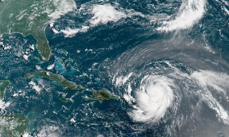
By the time Erin was officially named a tropical storm, the system had already developed an identity of its own. Satellite images revealed a budding structure, one that hinted at future symmetry and organization. The National Hurricane Center began issuing regular advisories, and suddenly the storm that looked like “just another wave” had become a significant topic among experts, coastal residents, and storm trackers across the Atlantic basin.
The Rapid Intensification and Forecast Challenges

One of the most remarkable features of Hurricane Erin 2025 was the speed at which it intensified. Rapid intensification—defined as an increase of at least 35 mph in sustained winds within 24 hours—isn’t uncommon in the Atlantic, but Erin’s leap from a strong tropical storm to a Category 3 hurricane was faster than most early-season forecasts had predicted. This sharp escalation left forecasters juggling new models, fresh data, and last-minute adjustments to track and intensity predictions.
Rapid intensification always complicates forecasting because it reduces the margin for error. Once Erin began strengthening more quickly than expected, meteorologists had to balance experience with objective model output. Some models suggested that wind shear would weaken the storm, while others showed that Erin could maintain its structure long enough to reach major hurricane status. When the storm punched through unfavorable conditions and intensified anyway, it became an example of how complex and unpredictable atmospheric dynamics can be, even with modern forecasting tools.
The head-scratching moment for many experts came when Erin maintained major-hurricane status longer than anticipated. Typically, storms lose strength as they encounter wind shear, dry air, or cooler waters. Erin navigated each of those obstacles like a storm with a mission. It dipped slightly in intensity at times, but its inner core remained strong enough to recover quickly. This resilience made Erin a perfect case study in storm structure integrity and sparked new discussions about how emerging climate patterns may be affecting hurricane behavior.
While Erin eventually plateaued, its rapid rise made it a favorite talking point among meteorologists. It demonstrated how far forecasting has come—but also how much the atmosphere still surprises even the most experienced experts. Erin became the kind of storm that pushed model developers and climate scientists to revisit assumptions about storm behavior in warming oceans.
The Human Impact and Preparedness Response
Hurricane Erin 2025 also highlighted something incredibly important: the evolving relationship between forecasting technology and human preparedness. As the storm approached populated areas, emergency management teams activated early response plans, and communities began the familiar but often stressful ritual of storm preparation. The speed of Erin’s intensification meant that some communities had less time to prepare than they expected, leading to a renewed focus on rapid-response communication.
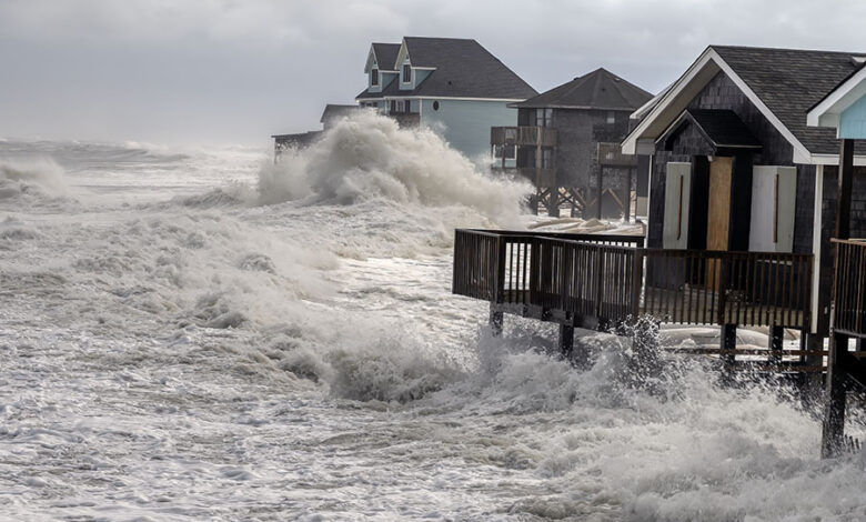
Despite the tight timeline, the advance forecasting tools and early advisories helped keep many people safe. Social media updates, automated alerts, and streamlined evacuation routes played a critical role in minimizing impact. Erin’s path included a series of near-misses, grazes, and glancing blows that caused localized damage but avoided catastrophic destruction in many regions. Still, the storm was powerful enough to cause coastal flooding, widespread power outages, and significant property damage in the areas where its outer bands passed closest.
One of the more striking outcomes of Erin’s passage was the improved coordination between meteorological agencies and emergency response networks. After previous seasons highlighted gaps in preparedness systems, many regions had upgraded their communication channels and emergency policies. Erin tested these improvements—and, in many cases, validated them. Residents reported receiving faster warnings, clearer evacuation guidelines, and better access to resources before and after the storm.
Yet, even with effective communication and planning, Erin’s impact served as a reminder that no system is perfect. Some communities struggled with last-minute surges in evacuees, while others faced supply shortages due to shipping interruptions. The storm brought to the forefront the importance of continuous improvement in emergency planning, particularly in a world where weather patterns evolve more rapidly than before.
Environmental and Climate Considerations
Another major conversation surrounding Hurricane Erin 2025 focused on its connection to broader climate trends. As scientific studies continue to link warmer ocean temperatures to stronger and more frequent hurricanes, Erin became part of a growing narrative about how climate change may be reshaping the Atlantic hurricane landscape. While one storm can’t be used to define broader climate patterns, Erin served as a meaningful data point in a larger ongoing discussion.
Climate researchers noted that Erin formed over waters warmer than the historical average for that time of year. The storm’s ability to maintain strength even in marginal conditions also raised questions about how atmospheric energy distribution is shifting. Was Erin an example of extreme variability, or a preview of more consistent trends in future seasons? That question remained open, but the storm certainly contributed valuable insight for climate model updates and future projections.
Environmental impacts extended beyond atmospheric considerations. Erin’s strong waves and storm surge affected coastal ecosystems, stirring up sediment, disrupting marine habitats, and altering shorelines. Mangrove systems, coral reefs, and marshlands—all crucial natural buffers against storm damage—experienced varying degrees of stress. Environmental groups emphasized the importance of continued restoration efforts in these regions, noting that healthier ecosystems often rebound faster after storms.
The storm also sparked new discussions about infrastructure resilience. As coastal communities continue to expand, the balance between environmental preservation and human development is becoming more critical. Erin’s impact reinforced the message that long-term planning must account not only for current storm patterns but also for the increasing unpredictability brought on by climate variability.
What Hurricane Erin 2025 Teaches Us Moving Forward
In retrospect, Hurricane Erin 2025 wasn’t just another name on the season’s list—it was a storm that tested prediction models, preparedness systems, and our understanding of modern hurricane behavior. It served as a reminder of the delicate balance between nature’s power and human readiness, challenging both experts and communities to stay adaptable.
Erin showed that storms can intensify faster and behave more unpredictably than expected, which underscores the need for continual innovation in meteorological science. It highlighted the importance of strong communication systems and community resilience, demonstrating that preparedness can significantly reduce risk even when the weather doesn’t cooperate. At the same time, the storm renewed conversations about climate change, environmental stewardship, and infrastructure planning for decades ahead.
As each hurricane season unfolds, Erin will likely remain a reference point for forecasters and emergency planners. It stands as a compelling example of how even one storm can influence policies, inspire new research, and remind us that vigilance remains our best defense against nature’s most powerful forces.


